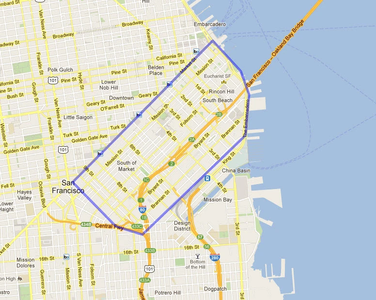
The South of Market neighborhood (often called the SoMa) is a relatively large neighborhood of San Francisco, consisting of several smaller sub-neighorhoods including South Beach and Rincon Hill. It is generally considered to be bordered by Market Street along the northwest, the Embarcadero and Townsend Street along the north, northeast, and east, and 11th Street along the southeast, although exact delineations are often debated and can vary slightly.
History[]
In 1847, the then pueblo (village) of San Francisco extended its boundaries in a southerly direction by creating a new subdivision. At the time, the streets of San Francisco were aligned (approximately) with the compass points, running north to south, or east to west. Each block was divided into six lots 50 varas on a side. (A vara is about 33 inches.) O'Farrell decided that the streets in the new subdivision should run parallel with or perpendicular to the only existing road in the area, Mission Road (later Mission Street), and thus be aligned with the half-points of the compass, i.e., northeast to southwest, and northwest to southeast. O'Farrell also decided to make the new blocks twice as long and twice as wide, with each lot 100 varas on a side. Finally, O'Farrell created "a grand promenade" linking the old pueblo with the new subdivision, Market Street.[14] Since then, downtown San Francisco north of Lower Market Street has been officially known as 50 Vara, while the South of Market area is officially known as 100 Vara.
During the mid-19th century, SOMA became a burgeoning pioneer community, largely low-density residential, except for a business district that developed along 2nd and 3rd streets, and emerging industrial areas near the waterfront. Rincon Hill became an enclave for the wealthy, while nearby South Park became an enclave for the upper middle class. By the early 20th century, heavy industrial development due to its proximity to the docks of San Francisco Bay, with the advent of cable cars, had driven the wealthy over to Nob Hill and points west, as the neighborhood became a largely working-class and lower-middle-class community of recent European immigrants, sweatshops, power stations, flophouses, and factories.
The 1906 earthquake completely destroyed the area, as many of the quake's fatalities occurred there. Following the quake, the area was rebuilt with wider than usual streets, as the focus was towards the development of light to heavy industry. The construction of the Bay Bridge and the U.S. Route 101 during the 1930s saw large swaths of the area demolished including most of the original Rincon Hill.
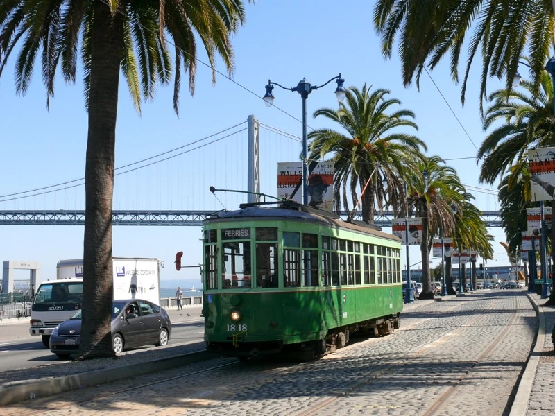
From the late 19th century to the mid-20th century, the South of Market area was served by several streetcar lines owned by the Market Street Railway Company, including the No. 14 Mission Street electric railway line, the No. 27 Bryant Street line, the 28 Harrison, 35 Howard, 36 Folsom, 41 Second and Market, and the No. 42 First and Fifth Street line.
Throughout the 1940s and 1950s, South of Market was home not only to warehousing and light industry, but also to a sizable population of transients, seamen, other working men living in hotels, and a working-class residential population in old Victorian buildings in smaller side streets and alleyways giving it a "skid row" reputation.
The waterfront redevelopment of the Embarcadero in the 1950s pushed a new population into this area in the 1960s, the incipient gay community, and the leather community in particular. From 1962 until 1982, the gay community grew and thrived throughout South of Market, most visibly along Folsom Street. This community had been active in resisting the City's ambitious redevelopment program for the area throughout the 1970s. But as the AIDS epidemic unfolded in the 1980s, the ability of this community to stand up to downtown and City Hall was dramatically weakened. The crisis became an opportunity for the City (in the name of public health) to close bathhouses and regulate bars---businesses that had been the cornerstone of the community's efforts to maintain a gay space in the South of Market neighborhood.
In 1984, as these spaces for gay community were rapidly closing, a coalition of housing activists and community organizers started the Folsom Street Fair, in order to enhance the visibility of the community at a time when people in City Hall and elsewhere were apt to think it had gone away. The fair also provided a means for much-needed fundraising, and create opportunities for members of the leather community to connect to services and vital information (e.g., regarding safer sex) which bathhouses and bars might otherwise have been ideally situated to distribute.
Physical Features[]
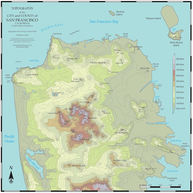
Topographic map of SF
The South of Market neighborhood is one of the topographically "un-San Franciscan" neighborhoods in that it is almost entirely flat. It has only one recognized "hill," Rincon Hill. This made it a more practical location for the warehousing industry of San Francisco in the 19th century.
Attractions[]
The neighborhood is a vast and diverse stretch of warehouses, auto repair shops, nightclubs, residential hotels, art spaces, loft apartments, furniture showrooms, condominiums, and technology companies.
Despite the Dot-Com crash of the early 2000s, major software and technology companies have headquarters here, including Wikia, Wired, Sega of America Inc., CNET Networks, Twitter, Dropbox, Justin.tv, BitTorrent Inc., Yelp, Zynga, Rapleaf, and Advent Software among others. The area is also home to the few Big-box stores in San Francisco such as Costco, REI, Nordstrom Rack, and Best Buy. South Park (no relation to the popular animated TV series) is often credited to be the location of where the Dot-Com boom began in the 1990's.
South Park in the SoMa.
SOMA is home to many of San Francisco's museums, include SFMOMA, the Yerba Buena Center for the Arts, and the Museum of the African Diaspora. The Cartoon Art Museum, the children's Zeum, and the Contemporary Jewish Museum are also in the Yerba Buena area. The Old Mint, which served as the San Francisco Mint from 1874 to 1937, has been restored and is schedule to reopen to the public in 2012 following an 8-year renovation. The Center for the Arts, along with Yerba Buena Gardens and the Metreon, is built on top of Moscone North. Across Howard Street, built on top of Moscone South, is a children's park featuring a large play area, an ice skating rink, a bowling alley, a restaurant, the Zeum, and the restored merry-go-round from Playland-At-the-Beach. The children's park and Zeum are joined to Yerba Buena Gardens by a footbridge over Howard Street.
Many small theatre companies and venues add to the cultural attraction of the SOMA, such as the Lamplighters, The Garage, Theatre Rhinoceros, Boxcar Theater, Crowded Fire Theater, Off-Market Theaters, FoolsFURY Theater, and Climate Theater.
Because of its Gay Rights history, the Folsom Street Fair is held on Folsom Street between 7th and 12th streets. The smaller and less-commercialized but also leather subculture-oriented Up Your Alley Fair (commonly referred to as the Dore Alley Fair) is also held in the neighborhood, in late July on Folsom between 9th and 10th streets and in Dore Alley between Folsom and Howard. Also home to the annual How Weird Street Faire featuring dancing and costumes, held in early May along seven city blocks including Howard and Second streets.
Public health facilities in the area include the South of Market Health Center. Those seeking sexual health make use of the district's San Francisco City Clinic to get STD tests and treatment in addition to counseling and condoms.
Because the streets in the area are aligned with the half-points of the compass, people's sense of direction tends to get skewed 45 degrees clockwise. Thus, while driving towards Market Street, people have the sense that they are driving "northbound" even though it is actually northwest, the same principle applying to the other three cardinal directions.
South Park[]

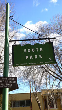
The sign at the southwestern end of South Park.
The park was originally constructed in 1855 as the center of an exclusive residential community. It was modeled after a square in London, England, as a housing development of seventeen mansions plus townhouses (a total of 58 residences) on a 550-foot oval around a private grassy park. It featured the first paved streets and sidewalks in San Francisco. A windmill in the center of the park pumped water for the houses.
The neighborhood began to lose exclusivity after the construction of Second Street, which made the area accessible to less affluent residents. Rich residents moved to the newer Nob Hill neighborhood in the late 19th century, and the city took over the park in 1897. It suffered further decline after the San Francisco earthquake of 1906, when most of the homes around the Rincon Hill neighborhood were destroyed. The oval park, however, has remained unchanged and is still a central meeting place in the neighborhood. After the quake the neighborhood was rebuilt as warehouses, light manufacturing, nightclubs, and hotels. Immigrants from various countries came to the neighborhood, as well as longshoremen, drug addicts, and vagrants. The neighborhood began to attract artists and young professionals beginning in the 1970s.
The area flourished during the dot-com boom of the late 1990s, due to flexible office space at initially low rent. It was sometimes described as "ground zero" of the dot com revolution, with many start-up Internet companies based in the area. By late 2001, however, many of these companies had closed their doors. Yet, as of 2006, in an era for the Internet that some have dubbed Web 2.0, South Park has once again become home to many small Web-related companies.
Recently, some neighbors in South Park have expressed opposition to a proposal to put an above-ground stop on the Central Subway at the southwestern end of South Park Street, on Third Street. Finally the routing of the line has been decided by the Municipal Transportation Agency, and will be along Fourth Street, one block farther west.